Last Chance: The Art of Cartography Closes October 16!
This weekend will be your last chance to visit our free exhibit, The Art of Cartography, on display in the Toronto Reference Library's TD Gallery. The exhibit runs until this Sunday, October 16.
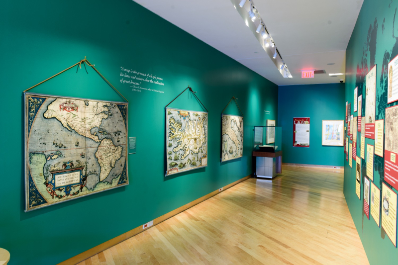
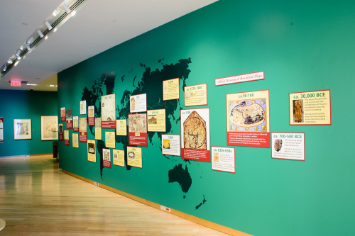
The exhibit begins with a brief timeline charting some of the major developments that influenced the look of maps from the earliest celestial maps, carved into stone or tusk, to the current age of satellite mapping and Google Earth.
The Art of Cartography reveals that the way maps look can'tell us a lot about who was doing the mapping, for what purpose, and for whom.
Many of the maps on display originally served "functional" purposes: to help explorers navigate from point A to point B, to define (and claim) political boundaries and territories, or simply to help educate their audiences about world geography.
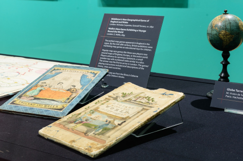
Middleton's New Geographical Game of England and Wales, London: Nicholas Carpenter, Goswell Terrace, ca. 1850, Osborne Collection of Early Children's Books; Right: Wallis's New Game Exhibiting a Voyage Round the World, London: E. Wallis, 1835, Osborne Collection of Early Children's Books.
The exhibit features several examples of "maps" designed as educational tools. Above are two examples of "map race games" from the 19th century, popular toys aimed at teaching geography to British school children. The object of the game was to race around maps of England, Europe or the entire world. Players advance by spinning a teetotum, a small wooden top with numbered sides similar to a dice. The winner was the first to arrive in London. The games’ playing instructions include brief descriptions of the towns, cities and countries.
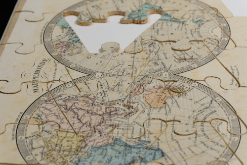
Mappemonde puzzle, R. Fremin, 1810-1860, Paris: Auguste Logerot, ca. 1842
Did you know that the earliest jigsaw puzzles were "dissected maps," created to teach geography to children? John Spillsbury is credited with creating the first jigsaw puzzle, a divided map of Europe, in the 1760s.The double hemisphere map shown above was originally part of a set of puzzles or a “puzzle atlas.” It was drawn by A. R. Fremin, a French geographer.
 Eslick's Patent puzzles, Steven Joseph Eslick, 1851-1904; Engraved by W. Hughes, London & Liverpool: George Philip, Son & Nephew, ca. 1880, Osborne Collection of Early Children's Books
Steven Joseph Eslick was an inventor from Birmingham. In 1878 he obtained a patent for an "improvement in geographical maps." The patent was for the process of dissecting a map while leaving the edges intact as a frame for the puzzle. The 1880 set above includes six dissected puzzles: maps of Europe, France, Scotland, the United States, Ireland, and England and Wales. The Art of Cartography exhibit includes a touch-screen interactive where you can'try your hand at completing a few of Eslick's map puzzles.

Charlotte's miscellany, or, Universal guide containing amusing & useful information upon various subjects, Kempton Park: Printed by Harriet Petrie, ca. 1805, Osborne Collection of Early Children's Books
This sweet hand-written compendium of knowledge was created by a young British girl named Harriet Petrie as a birthday gift for her sister, Charlotte, on her ninth birthday. The section on “Geography” includes five original fold-out maps. There are also sections on reading, grammar, history, astronomy, natural history, arithmetic and drawing.
In the early 19th century, schoolgirls in Canada, the United States and the United Kingdom were expected to draw maps, either by copying or tracing existing maps. Boys were more often taught surveying and navigation. This was not to prepare young girls to be cartographers or geographers, but for them to practice and demonstrate their artistic skills, penmanship and attention to detail.
An Art of Cartography Scavenger Hunt!
Are you planning to visit the exhibit with young map enthusiasts or explorers-in-training? Send them on a scavenger hunt to discover some of the weird and wonderful maps in the exhibit.
Can you find:
- A map decorated with sea monsters?
- A map of the North Pole?
- A map made by a famous explorer?
- A map decorated with pictures of animals?
- A map that shows something strange about California?
- A map with a cartouche? (What is a cartouche?)
- A map that shows a place that never really existed?
- A map that shows the pyramids?
- A map that was drawn by hand? (What do we call hand-drawn maps?)
- A map that shows a place you have lived or visited?
Want to learn more about The Art of Cartography?
Check out some of our previous blog posts or explore our Digital Archive to discover some of the highlights from the exhibit – including sea charts and celestial maps, city plans and views, and some curious-looking maps of newly "discovered" lands and invented islands.
4 thoughts on “Last Chance: The Art of Cartography Closes October 16!”
Thank you for the reminder. Also the scavenger hunt worked out well for my youngest to get engaged with the exhibit. Had us stumped for a bit though as one of the answers isn’t in the gallery, but outside.
There seemed to be an error in one of the information boards. Does the exhibit travel at all and should it be corrected before then, or not bother since it only has a couple days left?
Hi Chris,
I’m glad your youngest enjoyed the scavenger hunt.
The exhibit is now closed and not expected to travel, but I’d still like to know about the error you found. Feel free to send an email with more details to: ndawkins@torontopubliclibrary.ca
Hi Chris,
I’m glad your youngest enjoyed the scavenger hunt.
The exhibit is now closed and not expected to travel, but I’d still like to know about the error you found. Feel free to send an email with more details to: ndawkins@torontopubliclibrary.ca